|
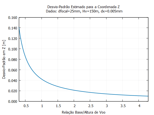
Exemplo 1 - Função que representa a estimativa do desvio-padrão
da coordenada Z, no espaço objeto, a partir da interseção fotogramétrica de um par de
imagens verticais. Example 1 - Function representing the estimate of the standard deviation of the Z coordinate, in object space, from the photogrammetric intersection of a pair of vertical images. |
|
Dados de entrada: distância focal da câmara, altura de voo e desvio-padrão da fotocoordenada medida na imagem. |
 |
|
# -------------------------------------------------------------- # Estimativa do desvio-padrão da coordenada Z, no espaço objeto, # a partir da interseção fotogramétrica de imagens verticais # # Referência: [1], pág. 27 # # Autor: M. Galo, UNESP / Dep. de Cartografia # 2022 # reset unset mouse set xrange [0.3:4.3] set xtics 0.5 set dummy rBZ set key right top set angles degrees set grid set format y "%5.3f" # Distância focal [mm] dfocal = 25 # Altura de voo [m] Hv = 150 # Desvio-padrão na medida da fotocoordenada [mm] dx = 0.005 # Desvio-padrão da paralaxe dpp = sqrt(2)*dx # Desvio-padrão da coordenada Z no espaço objeto [m] dpZ(rBZ) = (Hv/dfocal)*dpp/rBZ set title "Desvio-Padrão Estimado para a Coordenada Z \n Dados: dfocal=25mm, Hv=150m, dx=0.005mm" set xlabel "Relação Base/Altura de Voo" set ylabel "Desvio-Padrão em Z [m]" plot dpZ(rBZ) t"" with lines lc 6 lw 2 pause -1 "Fechar?" |